


 |
||||
Yahata Plateau Yahata Plateau is an elevated basin in the Chugoku Mountains along the
Shibaki River, a branch of the Ota River, at the western end of former Geihoku-cho (present Kitahiroshima-cho). The downstream portion of Shibaki River forms the valleys of Sandankyo. The plateau lies within the Western Chugoku Mountains Quasi National Park. In the basin, there is a wet-land including habitats of irises and various kinds of animals and plants important for researchers. Camping grounds are provided on the Hijiri Lake side and Mt. Ungetsu. Ski areas include Geihoku Bunka Land, Miwa, Ginrei, and Ojika Plateau Skiing Ground, with skiers coming from as far as the Kyushu region. In the surrounding mountains, there are natural forests of deciduous trees, including Japanese oaks and beeches, which are rare in southwestern Japan. Garyu Mountain is especially famous. Visitors to the Miwa district can enjoy tracing the history of ancient iron making in Japan at the Miwa Folk Art Museum, the remains of an ancient iron making site with a brick chimney. Geihoku Folkcraft Museum on the shore of Hijiri Lake (Tarutoko Dam) displays as many as 479 items of household appliances and folk handicrafts. An ancient naka-mon style house that was submerged under the water of Tarutoko Dam in 1957 has been reproduced to convey the lifestyle of the ancestors of the Tarutoko residents. It has been designated as an important tangible folk- cultural property of Japan. In April, grass on Mt. Ungetsu is lit on fire, using Izumo Shrine's sacred fire, to proclaim the coming of spring. 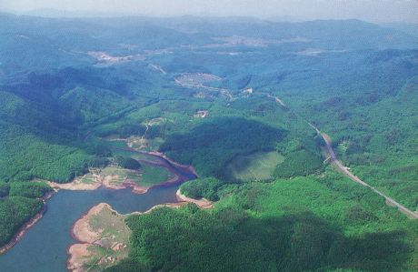
PhotoHijiri Lake in the foreground (Photograph taken circa 1994)
Memo
|